Where was Lower Harrington Street, Toxteth
-
aop27
Where was Lower Harrington Street, Toxteth
Does anyone know where Lower Harrington Street was around 1850-1860? I've seen the same address (No 60) variously referred to as Lower Harrington Street and also simply Harrington Street. Its always referred to as Toxteth and I can see an Upper Harrington Street both on today's map and on the 1847 OS map which makes me suspect that Lower Harrington Street must be somewhere near - but I can't spot it!

Lower Harrington Street
Hi,
The 1861 census summary sheet has #1Lower Harrington Street immediately following 3 House, 9 Court, Croston Street [at least it looks like Croston Street] without a break.
Haven't found Croston Street yet though.... It isn't indexed in the 1871, '81, or '91, so I think it may well have been built over and Lower Harrington Street with it, as suggested by Daggers.
In 1851 [HO107 piece 2187 folio 199 page 27], the summary page reads after #62 Grafton Street: "The end of the west side of Grafton St". The notation is immediately followed by #67 Lower Harrington Street.
Grafton Street is here: http://www.liverpoolhistoryprojects.co. ... az/T11.htm
DS
DS
Member # 7743
RIP 20 April 2015
Emery, McAnaspie/McAnaspri etc, Fry, McGibbon/McKibbion etc, Burbage, Butler, Brady, Foulkes, Sarsfield, Moon [Bristol & Cornwall].
Census information is Crown Copyright http://www.nationalarchives.gov.uk/
Member # 7743
RIP 20 April 2015
Emery, McAnaspie/McAnaspri etc, Fry, McGibbon/McKibbion etc, Burbage, Butler, Brady, Foulkes, Sarsfield, Moon [Bristol & Cornwall].
Census information is Crown Copyright http://www.nationalarchives.gov.uk/
-
aop27
Found it! Definitively found on the 1847 OS map. Its not been built over - it stil exists today as Caryl Street. Brunswick Railway Station fronts (maybe backs - not clear on the map) onto it. Between Grafton Street and Sefton Street. Also has a gas works and the Mersey Steel and Iron Works on it (Kaber Court today) at the south end and a Borax Works , Turpentine Distillary and several timber yards at the north end.
Thanks All - it was dickiesam's reference to Grafton Street that got me searching in the right place.
Thanks All - it was dickiesam's reference to Grafton Street that got me searching in the right place.
Harrington Street?
Hi Andrew,
Good result! Glad to have been of help.
DS
Good result! Glad to have been of help.
DS
DS
Member # 7743
RIP 20 April 2015
Emery, McAnaspie/McAnaspri etc, Fry, McGibbon/McKibbion etc, Burbage, Butler, Brady, Foulkes, Sarsfield, Moon [Bristol & Cornwall].
Census information is Crown Copyright http://www.nationalarchives.gov.uk/
Member # 7743
RIP 20 April 2015
Emery, McAnaspie/McAnaspri etc, Fry, McGibbon/McKibbion etc, Burbage, Butler, Brady, Foulkes, Sarsfield, Moon [Bristol & Cornwall].
Census information is Crown Copyright http://www.nationalarchives.gov.uk/
Re: Where was Lower Harrington Street, Toxteth
Thanks I have been looking for that street as well. 

Re: Where was Lower Harrington Street, Toxteth
Both Harringtons in Toxteth Park are shown here in this map from 1835:-
Blue

Blue
Member No. 8038
NIL SATIS NISI OPTIMUM
NIL SATIS NISI OPTIMUM
Re: Where was Lower Harrington Street, Toxteth
Thanks Blue.
It was called lower Harrington street in the 1841 and 1851 censuses.
Using the first page, thanks for the tip, it runs from Stanhope St To Parliament street.
It also mentions crow St and Sefton St. South side of Edna st. Quay marsh side of Coberg st? Further thoughts please.
Lynne (you could do this as a job)
Re: Where was Lower Harrington Street, Toxteth
Hi Lynne,
Are you still unsure about this location? Caryl Street used to be called Harrington Street or Lower Harrington Street.
My map shows the two Harringtons:-
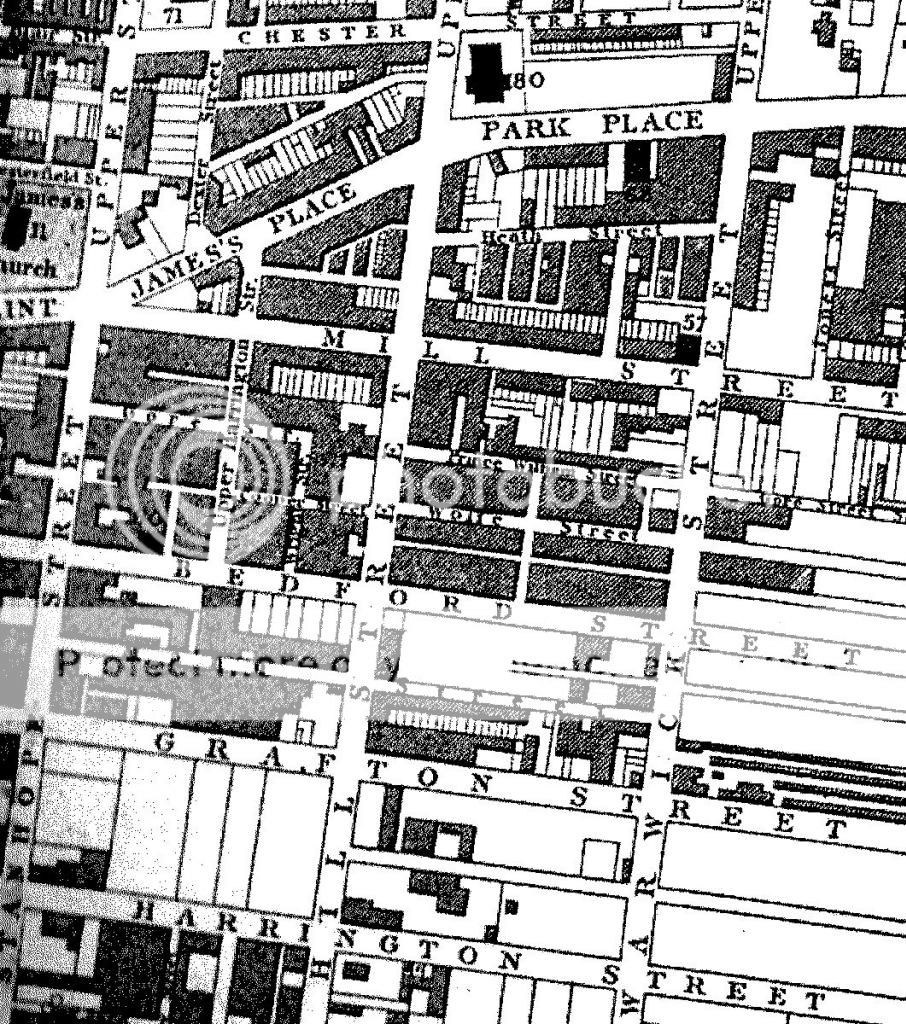
1. Upper Harrington Street - Between James Place and Bedford Street (now called Beaufort Street).
2. Harrington Street - Off Stanhope Street (also called Lower Harrington Street now called Caryl Street).
Blue
Are you still unsure about this location? Caryl Street used to be called Harrington Street or Lower Harrington Street.
My map shows the two Harringtons:-
1. Upper Harrington Street - Between James Place and Bedford Street (now called Beaufort Street).
2. Harrington Street - Off Stanhope Street (also called Lower Harrington Street now called Caryl Street).
Blue
Member No. 8038
NIL SATIS NISI OPTIMUM
NIL SATIS NISI OPTIMUM
Re: Where was Lower Harrington Street, Toxteth
Thanks Blue. did not know which one it was though I guess with them living at 70, then the longer Street would be it.
Thanks again
Lynne
Thanks again
Lynne