I hope someone may be able to point me towards a large scale map of the area round St Thomas's church, at the end of Park Lane, around 1800, please.
Daggers
Liverpool map around 1800

Re: Liverpool map around 1800
I'm not aware of a detailed one for around that time online but I like the look of this map of Liverpool by R Horwood from 1803 maybe you can get to see it and take a photo:-
http://www.liverpoolmuseums.org.uk/mari ... 21000.aspx
Blue
http://www.liverpoolmuseums.org.uk/mari ... 21000.aspx
Blue
Member No. 8038
NIL SATIS NISI OPTIMUM
NIL SATIS NISI OPTIMUM
Re: Liverpool map around 1800
That may be what I am looking for so will try to see it. Thanks, Blue
D
D
M. no. 31
Re: Liverpool map around 1800
Not what you want but interesting links about St Thomas Church & churchyard and a c1848 map:-
https://liverpool1207blog.wordpress.com ... liverpool/
https://library.thehumanjourney.net/150 ... Report.pdf
c1848
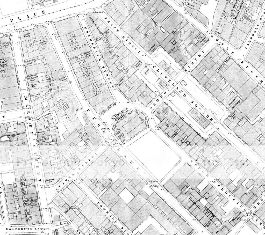
Blue
https://liverpool1207blog.wordpress.com ... liverpool/
https://library.thehumanjourney.net/150 ... Report.pdf
c1848

Blue
Member No. 8038
NIL SATIS NISI OPTIMUM
NIL SATIS NISI OPTIMUM
Re: Liverpool map around 1800
Vey interesting, especially the number of pubs. You would be hard pressed to have a pint in each in one evening!
D
D
M. no. 31

Re: Liverpool map around 1800
daggers wrote:the number of pubs. You would be hard pressed to have a pint in each in one evening
MaryA
Our Facebook Page
Names - Lunt, Hall, Kent, Ayre, Forshaw, Parle, Lawrenson, Longford, Ennis, Bayley, Russell, Longworth, Baile
Any census info in this post is Crown Copyright, from National Archives
Our Facebook Page
Names - Lunt, Hall, Kent, Ayre, Forshaw, Parle, Lawrenson, Longford, Ennis, Bayley, Russell, Longworth, Baile
Any census info in this post is Crown Copyright, from National Archives
Re: Liverpool map around 1800
My interest has stretched to the area known as 'Nova Scotia', which was probably a little nearer Mann Island, from what I remember. Any chance of another reference?
Daggers
Daggers
M. no. 31
Re: Liverpool map around 1800
Nova Scotia, Irwell St, Mann Island, 1911 Directory.
http://maps.nls.uk/geo/explore/sidebysi ... ht=BingHyb
http://maps.nls.uk/geo/explore/sidebysi ... ht=BingHyb
Bert
Re: Liverpool map around 1800
I can't find a decent sized mid 19th century map with pub detail unfortunately. The directories may help with the early pub names. Later maps include pub names in the area such as Dicky Sam Inn, Old Lifeboat, Old House, Oddfellows' Arms and Packet House.
Blue
Blue
Member No. 8038
NIL SATIS NISI OPTIMUM
NIL SATIS NISI OPTIMUM
Re: Liverpool map around 1800
Thanks once again, Blue. The map is just what I wanted to show where a family member once worked, but I was not on a pub crawl this time!
D
D
M. no. 31